New NASA Instrument for Studying Snowpack Completes Airborne Testing

Summer heat has significant effects in the mountainous regions of the western United States. Melted snow washes from snowy peaks into the rivers, reservoirs, and streams that supply millions of Americans with freshwater—as much as 75% of the annual freshwater supply for some states.
But as climate change brings winter temperatures to new highs, these summer rushes of freshwater can sometimes slow to a trickle.
“The runoff supports cities most people wouldn’t expect,” explained Chris Derksen, a glaciologist and Research Scientist with Environment and Climate Change Canada. “Big cities like San Francisco and Los Angeles get water from snowmelt.”
To forecast snowmelt with greater accuracy, NASA’s Earth Science Technology Office (ESTO) and a team of researchers from the University of Massachusetts, Amherst, are developing SNOWWI, a dual-frequency synthetic aperture radar that could one day be the cornerstone of future missions dedicated to measuring snow mass on a global scale – something the science community lacks.
SNOWWI aims to fill this technology gap. In January and March 2024, the SNOWWI research team passed a key milestone, flying their prototype for the first time aboard a small, twin-engine aircraft in Grand Mesa, Colorado, and gathering useful data on the area’s winter snowfields.
“I’d say the big development is that we’ve gone from pieces of hardware in a lab to something that makes meaningful data,” explained Paul Siqueira, professor of engineering at the University of Massachusetts, Amherst, and principal investigator for SNOWWI.
SNOWWI stands for Snow Water-equivalent Wide Swath Interferometer and Scatterometer. The instrument probes snowpack with two Ku-band radar signals: a high-frequency signal that interacts with individual snow grains, and a low-frequency signal that passes through the snowpack to the ground.
The high-frequency signal gives researchers a clear look at the consistency of the snowpack, while the low-frequency signal helps researchers determine its total depth.
“Having two frequencies allows us to better separate the influence of the snow microstructure from the influence of the snow depth,” said Derksen, who participated in the Grand Mesa field campaign. “One frequency is good, two frequencies are better.”

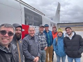
The SNOWWI team in Grand Mesa, preparing to flight test their instrument. From an altitude of 4 kilometers (2.5 miles), SNOWWI can map 100 square kilometers (about 38 square miles) in just 30 minutes.
As both of those scattered signals interact with the snowpack and bounce back towards the instrument, they lose energy. SNOWWI measures that lost energy, and researchers later correlate those losses to features within the snowpack, especially its depth, density, and mass.
From an airborne platform with an altitude of 2.5 miles (4 kilometers), SNOWWI could map 40 square miles (100 square kilometers) of snowy terrain in just 30 minutes. From space, SNOWWI’s coverage would be even greater. Siqueira is working with Capella Space to develop a space-ready SNOWWI for satellite missions.
But there’s still much work to be done before SNOWWI visits space. Siqueira plans to lead another field campaign, this time in the mountains of Idaho. Grand Mesa is relatively flat, and Siqueira wants to see how well SNOWWI can measure snowpack tucked in the folds of complex, asymmetrical terrain.
For Derksen, who spends much of his time quantifying the freshwater content of snowpack in Canada, having a reliable database of global snowpack measurements would be game-changing.
“Snowmelt is money. It has intrinsic economic value,” he said. “If you want your salmon to run in mountain streams in the spring, you must have snowmelt. But unlike other natural resources, at this time, we really can’t monitor it very well.”
For information about opportunities to collaborate with NASA on novel, Earth-observing instruments, see ESTO’s catalog of open solicitations with its Instrument Incubator Program here.
Project Leads: Dr. Paul Siqueira, University of Massachusetts (Principal Investigator); Hans-Peter Marshall, University of Idaho (Co-Investigator)
Sponsoring Organizations: NASA’s Earth Science Technology Office (ESTO), Instrument Incubator Program (IIP)
Share
Details
Related Terms
Source link


